Weather forecasts have long provided grounds for discussion, and sometimes controversy. While meteorologists could point to statistics demonstrating the overall accuracy of their predictions, one mistake was often enough to bring a hail of public criticism.
Observations of the weather provide the raw data upon which forecasts are built. As well as recruiting thousands of volunteers, meteorologists have extended the range of their observations through the use of new technology. The telegraph linked colonial observatories; radio enabled contact with ships at sea. Aircraft demanded accurate forecasts, but they also gave new access to the upper atmosphere.
Radar and satellites have further expanded the meteorologist's observational horizons. Meanwhile computers have enabled the construction of mathematical models to represent weather systems and predict their behaviour. But the development of meteorology has also brought a greater understanding of its limits. There will always be surprises.

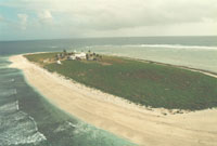
Buildings on Willis Island, a storm warning station in the Coral Sea, 1920s (see Peter Fletcher, 'Seventy-five years at Willis island')
The Weather Prophet
The weeks went by, the squatter wrote to tell his bank the news.
"'Ow can it rain," the old man said, "with things the way they are?
You've got to learn off ant and bee, and jackass and galah;
And no man never saw it rain, for fifty years at least,
Not when the blessed parakeets are flyin' to the east!"
"It's still as dry as dust," he said, "I'm feeding all the ewes;
The overdraft would sink a ship, but make your mind at rest,
It's all right now, the parakeets are flying to the west".
- A. B. (Banjo) Paterson
Article links
- Public attitudes towards weather forecasts and the limits of meteorology are explored in 'The Weather Prophets'
- Some of the implications of the telegraph to the development of meteorology are examined in 'Science and Technology in the Story of Australian Federation'
- The highs and lows of a forecaster's work are examined in 'The Life of George Grant Bond Early Queensland Weather Forecaster'
- Various developments in forecasting theory and technology are described in 'A Very Special Family'
- First-hand accounts of the development and use of radar and other electronic equipment are included in 'Stories of the Bureau's Radio Technical Officers from 1948'
|
<< BACK | HOME | ARTICLES | INDEX | NEXT >> |
Background image: The first weather map issued by the Commonwealth Bureau of Meteorology, Age, 2 January 1902.
Design & content: Tim Sherratt (tim@discontents.com.au)
Published by the Australian Science and Technology Heritage Centre, August 2001
http://www.austehc.unimelb.edu.au/fam/forecasting.html