

Antarctic Operational Meteorology
Abstract
Introduction
The Past
The Present
The Future
Acknowledgements
References
Index
Search
Help
Contact us

One of the principal (as contrasted with the geopolitical) reasons for the original establishment of the ANARE was the scientific, public and political perception that meteorological observations from the data-void region of the Southern Ocean south of Australia would enable a better understanding of the weather systems affecting southern Australia and lead to better short term (and possibly longer range) weather forecasts for the southern states. These views were founded on a wider knowledge among the community of the value of weather services following the Second World War. During the period of hostilities meteorological services expanded enormously among the combatant nations with the often critical requirement for information for strategic and tactical decisions particularly with respect to aviation and naval operations. (The classic and well documented example of this is the preparation of the forecasts for the D Day landings in Normandy in 1944).
In Australia, where the Bureau of Meteorology was integrated into the Royal Australian Air Force (RAAF) for the duration of the war, new networks of observation stations were established and extended to parts of the South West Pacific area; equipment for upper air soundings (radiosondes) on which modern meteorology depends were installed and new methods of data analysis commenced. While the staffing and resources available to the Bureau declined when it was "demobilised" it remained (for that era) reasonably well equipped and staffed with experienced people at the end of the decade of the forties. It was thus able to join the ANARE venture with enthusiasm in the general post-war spirit of adventure and optimism.
If a mean sea level (MSL) pressure chart analysis for the Australian region (ie. a daily weather map) were to be examined for a typical day in (say) 1946 it would be apparent that although the Australian continent had a reasonable coverage of surface weather observations the oceans particularly to the south were devoid of data except for the valuable observations from ships on the principal routes from South Africa, the Red Sea, South East Asia and New Zealand. Residents of southern Australia, recognised that much of the severe weather which they experienced, particularly but not only, in winter and spring occurred with invasions of cold air from the southwest and that these were poorly forecast. It was also well known by meteorologists that situations of severe weather and widespread heavy rain and flooding over Australia were frequently associated with the interaction of warm and moist air flowing from the lower latitudes of the Indian and Pacific oceans with abrupt cold changes from the south. It was clear therefore that observations from the Southern Ocean and perhaps as far south as Antarctica could provide advance warning of the arrival of cold air. In the middle to high latitudes of the North Atlantic and North Pacific where similar meteorological situations existed there was a considerable latitudinal spread of shipping traffic to provide observations and in addition several nations commissioned specially equipped "weather ships" to provide upper air soundings and more detailed surface weather and ocean observations at critical fixed locations. In the Southern Hemisphere the shipping routes were generally at lower latitudes, the ships were fewer and no government was prepared fund costly weather ships.
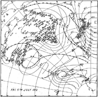
Despite these limitations to operational weather analysis some attempts were however being made to utilise data retrospectively from the publications resulting from earlier Antarctic expeditions to study the evolution of weather systems over the Southern Ocean. For example Figure 1 shows one of the sequences of daily synoptic analyses (that for 5 July 1912) constructed by Kidson (1947) and based on observations made by parties of Mawson's expedition on the Antarctic continent and at Macquarie Island and those for the same times taken by Scott's 1910–1912 expedition in the Ross Sea area as well as the observations from Australia and New Zealand. In this work Kidson introduced the then new techniques of air mass and frontal analysis developed for the Northern Hemisphere by the Norwegian school of meteorologists between the wars. In this theory attempts were made to identify the boundaries of various "air masses" having different temperature and moisture characteristics and associated with particular weather types within the air mass and at their boundaries. Only surface data were available as upper air observations of wind speed and direction, temperature and moisture from a network of stations in Australia and New Zealand became available only after the Second World War. Such studies however indicated the way in which regular observations from remote areas might be used in a continuing operational way with immediate practical applications.

People in Bright Sparcs - Kidson, Edward
 |
Bureau of Meteorology |  |
© Online Edition Australian Science and Technology Heritage Centre and Bureau of Meteorology 2001
Published by Australian Science and Technology Heritage Centre, using the Web Academic Resource Publisher
http://www.austehc.unimelb.edu.au/fam/1585.html